53rd Street Will Be Torn Up Until April For Water Main Project

Expect portions of 53rd Street to be torn up until at least next April as the city replaces a 127-year-old water main.

The Department of Water Management said it will install new water mains starting this month on 53rd Street between Dorchester Avenue and Hyde Park Boulevard and on Dorchester between 53rd and 55th streets.

It’s expected to take until December to install the 2,550 of new eight-inch water main.

Crews are scheduled to return in April to finish restoring the street.

Parking will be limited near the most active areas of the work area.

Water is expected to be shut off temporarily when the new pipes are brought online.

For more information or to sign up for updates on the project, visit BuildingANewChicago.org.

Albany Park Tunnel Looks So Cool, Too Bad It’s Underground

The $70 million Albany Park Stormwater Diversion Tunnel is the coolest-looking piece of infrastructure people will never get to see.

The newest image, snapped 150 feet below Foster Avenue, shows crews constructing the tunnel’s liners, which will be used to mold the pipe’s poured concrete.

Excavation of the 5,833-foot tunnel — which connects an inlet shaft near Springfield Avenue with an outlet shaft in River Park — was completed in September.

The contractor expects to begin pouring concrete this week continuing into November, according to the Chicago Department of Transportation.

Once the tunnel becomes operational, sometime in spring 2018, the pipe, 18 feet in diameter, will divert overflow from the Chicago River away from homes in Albany Park and North Park, releasing the water into the North Shore Channel downstream.

The tunnel was announced in 2013 after flooding that saw residents evacuated by boat. Construction began in 2016.

Move Over 606, City Officials Break Ground On 312 RiverRun Trail

It used to be Chicago’s defining area code. Now 312 has a new meaning. On Wednesday, Mayor Rahm Emanuel announced the 312 RiverRun: three parks, connected by a single path that stretches for nearly 2 miles on the Chicago River, from Belmont to Montrose.

“It combines the Riverwalk and the 606 into something new,” said Emanuel.

Elements of the 312 RiverRun have been in the planning stages for years. On Wednesday, city officials broke ground on the first phase of the path, the highly anticipated Riverview Bridge, which will, in parts, soar 18 feet above the river.

The bridge will provide pedestrians, cyclists and runners with a link between Clark Park on the east side of the river and California Park on the west. The second component of the 312 RiverRun includes repairs to the Irving Park Road bridge and the subsequent construction of an underbridge that will unite California and Horner Parks.

The vision is for the path to create a campuslike atmosphere among the three parks, which span Roscoe Village/North Center, Avondale, Irving Park and Albany Park.

The breadth of recreational opportunities offered by the parks is “second to none,” said Chicago Park District CEO and Supt. Michael Kelly, who ticked off amenities including ice rinks, tennis courts, dirt bike jumps, baseball diamonds and the WMS Boathouse rowing facility.

But accessing all of those options has been challenging for residents, with the parks cut off from each other by major roadways and the river itself, Kelly said.

With the RiverRun, people will be able to easily bike, walk or jog up and down the river between parks, he said.

The linkages will be “transformative” and another “iconic addition” to the city’s infrastructure, said Rebekah Scheinfeld, Chicago Department of Transportation commissioner.

Emanuel has long touted the Chicago River as the city’s second waterfront — a backyard to Lake Michigan’s front yard.

“These are neighborhood investments,” he said of the RiverRun. “This is for all the families who don’t want to drive to the lake. Now you can run along the water in your neighborhood.”

The 312 RiverRun represents a major step toward the goal of a continuous path along the entire riverfront. Construction of the Riverview Bridge, which will be the longest pedestrian river bridge in the city, demonstrates that it’s possible to overcome gaps along the waterway where there’s a lack of available land, said Jim Merrell, advocacy director for the Active Transportation Alliance.

“It’s a great example of creative design overcoming physical restraints,” Merrell said.

Margaret Frisbie, executive director of Friends of the Chicago River, said the trail would attract new people to the river and introduce them to the waterway’s magic, its potential and the need for ongoing activism.

“You’re building advocates to join in the work we’re doing,” Frisbie said.

Work on the Riverview Bridge is expected to run through next year and possibly into 2019, Scheinfeld said.

Repairs to the Irving Park Bridge are expected to get underway in 2018, she said.The projects are being funded with a combination of local, state and federal dollars.

CDOT Commissioner Rebekah Scheinfeld, Mayor Rahm Emanuel, State Representative Jaime Andrade and Chicago Park District CEO and Superintendent Michael Kelly break ground on the Riverview Bridge. Andrade and Kelly recalled a time when UPS had designs on the land that’s now Clark Park. Thanks to funds from Openlands, the acreage was purchased for the Park District, making the 312 RiverRun possible decades later. [DNAinfo/Patty Wetli]

The height of the Riverview Bridge will allow recreational paddling to continue on the waterway below. [Chicago Department of Transportation]

Lake Shore Drive/Stevenson Ramp Project Finally Nearing The End

There will be lane and ramp closures on the Stevenson Expy. as workers prepare to open a new two-lane ramp to northbound Lake Shore Drive.

The closures will happen overnight and in the early morning next week so workers can put in new overhead signs. At the end, a two-lane ramp from the northbound Stevenson Expy. to northbound Lake Shore Drive will be opened.

The northbound Stevenson will be reduced to one lane between the Dan Ryan Expy. and Lake Shore Drive 10 p.m.-5 a.m. Monday through Oct. 5, according to the Illinois Department of Transportation. All lanes will be closed for some 15-minute periods between 1-5 a.m. those days.

The ramp from the Stevenson to northbound Lake Shore Drive will be closed 10 p.m.-5 a.m. Monday through Oct. 5, but a detour will be available, IDOT said. That detour will direct traffic onto southbound Lake Shore Drive to the 31st Street exit, where it will re-enter northbound Lake Shore Drive.

Drivers should expect delays, IDOT said.

Crews have been working to rebuild the ramps between the Stevenson and Lake Shore Drive for the last two years.

The overall project is expected to be completed by the end of this year, weather permitting, IDOT said.

Designs Revealed For Low-Line Project Planned Under ‘L’ Tracks

Safety, creative lighting and noise were the hot topics at Tuesday’s Low-Line Project meeting.

Initial concepts for the under-the-“L” project at the Paulina and Ashland plazas were revealed in a presentation led by Andrew Moddrell from PORT Urbanism, the design firm working on the project, at a community meeting on Tuesday. Representatives from the Lakeview Chamber of Commerce and CTA were present, along with about 40 community members.

The Low-Line project envisions a continuous half-mile walkway beneath the Brown Line that would connect Southport Avenue and Paulina Street. The project was introduced in the 2011 Lakeview Area Master Plan as a means of connecting the neighborhood’s subdistricts and beautifying the neighborhood.

The design concepts are based on feedback gathered at a community meeting on March 28 and through online surveys since then. Much of the feedback was focused on safety and lighting concerns, as well as requests for public art.

Conversations with CTA representatives about the physical possibilities and constraints of these areas of the Brown Line also played an important role in informing the designs.

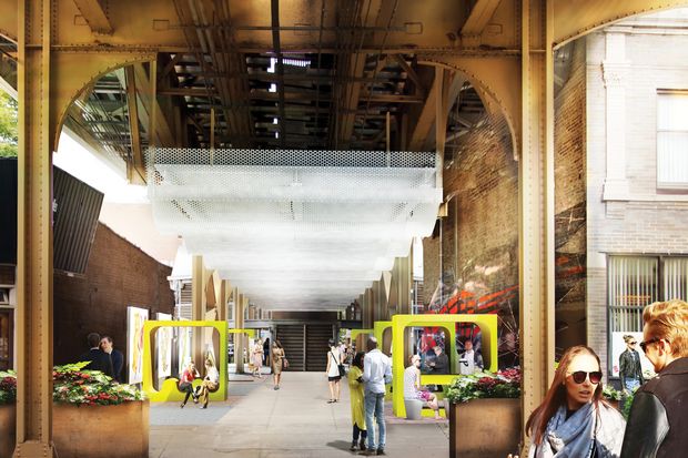
The concepts revealed for Paulina are reminiscent of Southport, as both serve as entrances to the Low-Line, and both are spots along the pathway where trains will come to a stop, making them less noisy than areas where the trains are driving straight through, like Ashland.

Some of the proposed features of the Paulina Plaza include overhead lighting, playful covered seating structures, finer gravel on the ground, spaces for food vendors and the same art panels that will go into Southport.

“We were trying to think of ways to create a space where you would hang around for just a minute but not all day, and not a space to host a lot of people or large events, but a place that could incorporate vendors and art,” Moddrell said. “We didn’t want to act like this was a space that was going to host long-term events or gatherings. But it can be a fun space you move through.”

The Ashland Plaza has a much simpler design for a few reasons: First, since trains run straight through that spot, the plaza would be an unlikely place for someone to spend much time lingering. Second, there are more constraints from the CTA: There is no access to power for lighting, nothing can be attached to the CTA structure, the structure itself will undergo construction to add concrete footing at some point over the next few years, and maintenance vehicles regularly use this pathway.

A rendering of the Ashland Plaza design concept revealed during Tuesday’s community meeting [Provided/PORT Urbanism]

Because of these factors, the Ashland Plaza concepts showed finer gravel on the ground, more art panels and interactive, programmable lighting columns that could also double as a public art piece. Finding a power source for these lights is still on the to-do list, Moddrell said.

After the presentation, community members asked questions and made comments on what they saw. One of the biggest concerns of the night was noise and whether the project makes sense given how unpleasant it is to be beneath train tracks.

But Moddrell pointed out the success of the Low-Line Market, which takes place at the Southport stop, as well as the frequency with which people already walk below CTA tracks throughout the city and including this stretch of the Brown Line. About 300 people filled out a survey on the Low-Line Project, and only 30 said they would not use the pathway even if it were completed, Moddrell said.

“Sound is just something we have to try to find a way to embrace with this because there’s very little we can do,” Moddrell said.

Another concern was the lack of crosswalks along the proposed pathway from Southport to Paulina. Moddrell said the only safe way to use the Low-Line would be to deviate from it to use a crosswalk when crossing streets. Some argued that it will be less likely to be used if it’s not a true, unbroken pathway, and Moddrell said lobbying for crosswalks in the future when the project is completed would fall to the community members.

Others voiced support for the project, saying it will make the affected areas safer and more pleasant to be around.

“Ultimately from the feedback from the CTA and the community, we are proposing that the Lakeview Low-Line could become both a fun and dynamic path for connecting Lakeview, but also a unique art destination in Chicago — something that brings people over from Wrigley Field or someone getting off the Brown Line to take a walk, but also something that draws out-of-towners,” Moddrell said. “It becomes both a really well-used daily path as well as a unique destination.”

Phase I of the plan has already seen improvements at Southport, including finer gravel on the ground, planters and tables and chairs, all of which are meant to make the plaza, which hosts the popular Low-Line Market, easier on the eyes.

The Paulina and Ashland plazas are also part of Phase I, and like Southport, they will be funded by Special Service Area 27, which receives tax money to perform basic services not provided by the city, including landscaping, holiday decorations and placemaking initiatives that would include the Low-Line. Phase I construction will take place next year.

Phase II of the project will see the development of the pathway connecting Paulina and Ashland, and Phase III will consist of the pathway connecting Ashland and Southport. Phases II and III will be funded by the non-profit Friends of Lakeview, which will solicit individual and corporate donations to see the project completed. There is currently no set timeline for Phases II and III.

Jeff Park Open Space Activists Arrive To Find Cars Parked On Event Site

Members of the neighborhood group Jefferson Park Forwardplanned to take over a handful of parking spaces outside the Jefferson Park Transit Center for a picnic spread Friday, employing what group president Ryan Richterdescribed as a “kind of guerilla tactic” aimed at nudging neighbors to re-imagine parking lots as pedestrian plazas.

But the event was thrown askew by opponents of Ald. John Arena (45th), who launched their own guerilla offensive.

Neighbors parked eight cars along the planned site of the event, planting signs in their windows reading “45th Ward says no to Arena.” Other signs read “45th Ward says no to Martwick,” referring to State Rep. Robert Martwick (D-Chicago).

In response, Jefferson Park Forward chose to relocate down the block, they said.

Arena’s staff took no part in planning the picnic, which was part of “Parking Day” — an annual multi-city event launched more than a decade ago in San Francisco to encourage the creation of more public spaces, Richter said.

But the second-term alderman has steadily pushed to open more space for pedestrians and cyclists across Jefferson Park, often at the expense of drivers — an agenda wholeheartedly endorsed by members of Jefferson Park Forward.

“People do value parking here, but we have a lot of it here in Jefferson Park,” said Susanna Ernst, a Jefferson Park Forward board member and one of the event’s organizers. “And realistically, I don’t think we need it. We’ve been sitting out here all day on a peak traffic day, and there have been empty spaces the whole time.”

Event organizers on Friday laid artificial turf over the pavement, then played lawn games, inviting passersby to write the names of their favorite neighborhood hangouts on folding chalk boards.

“The goal is for us to get community members to be talking about more creative ways to be using urban space,” Richter said. “We’re not necessarily saying there shouldn’t be parking here, but we wanted to highlight just how much of our community space is devoted to cars.”

After organizers saw the cars parked with protest signs in the windows outside the transit center early Friday morning, they decided to move their setup next-door to the Veterans Square parking lot to make clear that “it’s not a political event,” Richter said.

But the residents who parked the cars with the signs criticizing the aldermen — who didn’t remain on-site during the Jefferson Park Forward event — said they had intentionally left spaces open along Milwaukee Avenue so as not to disrupt Parking Day, according to a source close to the protesters.

“We wanted an opportunity to show that while JPF is out there, there’s a whole other side in the community that’s upset with the overall density agenda,” said the source, who asked to remain anonymous. “Residents are rising up and joining forces to take back our neighborhood.”

Arena has encouraged the development of a cluster of new multi-story apartment buildings in Jefferson Park since his 2015 re-election, citing a need to increase density and breathe life into the neighborhood’s downtown business district. The most recent proposal, to build a 100-unit mixed-income apartment complex at 5150 N. Northwest Hwy., has been controversial enough to spawn two new neighborhood advocacy groups all on its own.

Colleen Murphy, a board member of the Jefferson Park Neighborhood Association, stopped by the event on Friday morning to chat with organizers. Murphy and other association members have been fierce and consistent critics of Arena’s development agenda, but the group had no involvement in Friday’s silent counter-protest, she said.

“No one is ever trying to disrupt the events we put on, and we would never try and get in the way of someone else’s First Amendment right to be out here,” Murphy said. “And as far as parking goes, I think that’s an issue where everyone’s opinion can be met if we work together.”

You Can Now Schedule A Ride On Fixed-Route Lyft Shuttles 7 Days In Advance

Lyft is now giving rush hour commuters the ability to schedule their Lyft Shuttle rides seven days in advance.

Lyft Shuttle was unveiled in March as a rush-hour carpooling option in which drivers pick-up and drop-off passengers at certain intersections along a fixed route. The rides usually cost about $3 to $4 each and are only available 6:30 a.m. to 10:30 a.m. and 4 to 8 p.m.

Now that riders can schedule rides in advance, as opposed to just minutes before, riders can settle into a routine, Lyft said.

“It’s the perfect ride option for anyone who’s ever struggled to think straight before their first cup of coffee,” the company said.

“Shuttle is one of the many ways we’re working to reduce the number of empty seats on the street, so we can free up road capacity, and make it easier for everyone to get around our cities.

The new scheduling option allows riders to schedule between 15 minutes to 7 days before a needed ride. The app would notify riders eight minutes before their scheduled Shuttle arrives.

Earlier this year, Lyft said “rider and driver interest for Shuttle in Chicago is growing” and the service has had steady week-over-week growth. The service had started with three routes and expanding to six. The routes connect Downtown with Uptown, Wicker Park and Brighton Park.

While these initial Lyft routes were designed to cover high-demand areas, the rideshare company said it plans “to extend these low-cost rides to areas where affordable transit options are limited.”

Here’s an updated map of the routes that are currently running:

Get 19 Food And Drink Samples For $10 During North Center’s RestauranTour

Here’s a great way to get to know North Center — eat and drink your way through the neighborhood during Wednesday’s annual RestauranTour.

Each of the 19 participating restaurants and bars will offer a tasting portion of a signature dish or drink — for just $10 in advance or $15 at the door.

Ticketholders have four hours, 6-10 p.m., to visit as many venues as possible. Peruse the full list to plot a strategic route.

Here’s a sampling of what diners can expect: massaman curry from C’est Bien Thai, ceviche from Dos Ricco’s, empanadas from Melao Latin Cuisine and fried pies from Reclaimed, just to name a few.

Click here to register.

The event is sponsored by the Northcenter Chamber of Commerce, 4054 N. Lincoln Ave.

2 Bus Stops Removed On Friday To Make More Room For Bikes in Wicker Park

Two CTA bus stops have been eliminated and four others moved as part of a Chicago Department of Transportation pilot project that recently added “dashed bike lanes” to a busy stretch of Milwaukee Avenue.

Brian Steele, a CTA spokesman, said the bus stop changes took effect Friday, at the start of the service day.

A CTA No. 56 Milwaukee Avenue bus stop at Milwaukee and Ashland avenues near the Polish Triangle and a No. 50 Damen Avenue stop in front of Walgreens at 1601 N. Milwaukee Ave. were eliminated.

There are additional bus stops in close proximity to both of the removed stops.

The eliminated stop in front of the Walgreen’s now features bright green pavement markings on the street where the bus parked, clearly marking the space for cyclists.

Steele said the new bus stop configurations are not a temporary test and as, with all stops, the CTA will “continue to monitor their performance to see if any further adjustments are needed.”

The dashed bike lanes and intersection markers were painted on the pavement late last month, and earlier this week, signs explaining the bike lanes were posted to several intersections along the 1.2-mile stretch of Milwaukee Avenue between Division Street and Western avenue where.

The bus stop changes:

  • Eliminated SB Milwaukee at Ashland
  • Relocated NB Milwaukee at Paulina to Farside of Intersection
  • Eliminated SB Damen at Milwaukee/North
  • Relocated SB Milwaukee at Caton to Farside of Intersection
  • Relocated NB Milwaukee at Leavitt to Nearside of Intersection
  • Relocated SB Milwaukee at Western to Farside of Inrersection

New Metra Schedules For Electric, Rock Island Lines Begin Monday

New schedules for Metra’s Rock Island and Electriclines will go into effect Monday.

The agency announced last month it had finalized its revision of the Electric line’s schedule, making several adjustments in response to customer feedback at informational meetings and via email.

Visit Metra’s website for a complete list of the changes on the Electric line, including the restoration of one late-night outbound train on the South Chicago Branch.

Service on the electric line will also be restored Saturdays on the Blue Island Branch — albeit reduced to four inbound and four outbound trains.

As for Metra’s Rock Island line, the midday express service will revert to local service, ending a yearlong pilot program. There are other minor adjustments to the weekday schedule, but no changes to the weekend schedule.

For a complete list of the changes on both lines, visit Metra’s website. Printed schedules for both lines are also available in the stations this week.